


Two things motivate everything we do at Southlands: travel and nature. Both come together in our guides. Here’s the first edition, showcasing our home city of New Orleans.
New Orleans is a place under siege.
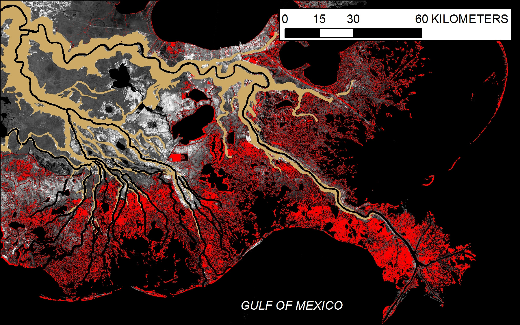
The ocean is rising. The water is creeping toward this city, which is walled away, medieval-style, since much of the terrain sits below the level of the sea.
How did this come to be? To understand the nature of this place, you’ve got to understand the behavior of the Mississippi River. For thousands of years, the river jumped across various routes, dumping mud into the ocean. The land grew outward like fingers reaching into the Gulf of Mexico.
The mud beneath New Orleans appeared just a few thousand years ago. There’s a good chance that it was occupied almost immediately; Indigenous people moved into fishing villages as soon as each new delta formed so as to exploit the rich mixture of fresh- and saltwater resources. By the eighteenth century, when the first European settlers arrived, the delta was known as a cosmopolitan place where river travelers mixed and mingled: Bulbancha, the Choctaw name for New Orleans (or maybe for the whole delta), means “the place of many languages.”
The first French buildings in New Orleans were built in 1718. The next few decades were rough: think river floods, hurricanes, epidemic diseases, constant warfare, economic turmoil. The new town endured, and, sited at the foot of an increasingly busy river, became the subject of various imperial dreams. By the time New Orleans became a U.S. possession in 1804, it was the country’s largest city beyond the east coast.
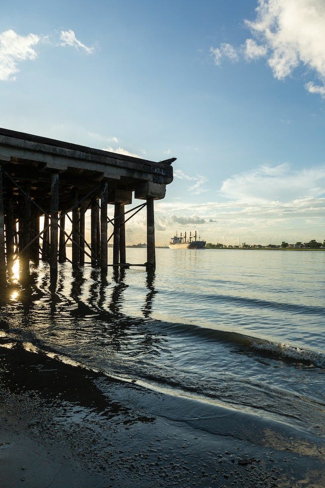
Today, there' is a different economy, though it’s still tied to the river: the of flow off the continent had carried rich organic materials into the ocean, which over tens of millions of years were converted into hydrocarbons. The first offshore oil rigs were built in the 1930s. Today, the banks of the river near the city are lined with industrial facilities that convert ancient fossils into plastic and chemicals and other fun and oh-so-cleanly goods.
Tourist Life on the Mississippi
🛥️: The best way to experience the Mississippi River is to traverse its water. And while you could book a ticket on a steamboat, it’s a lot cheaper—just $2!—to ride the ferry instead. It’s a short ride, but your destination, Algiers Point, is a perfect neighborhood to stroll.
🚶♀️: If you just want to stroll its banks, the river is easily accessible from the French Quarter. Just downstream, Crescent Park provides excellent views paired with preserved remnants of old wharves. My favorite walk along the river is in the Lower Ninth Ward: depending on the river level, you might get sandy beaches or groves of willow trees, paired with shipping facilities still in use. Plus lots of dogs.
🍸: For a good view over a glass of wine, check out Chemin A La Mer, which is on the fifth floor of the Four Seasons Hotel. Perhaps avoid the food, though, which I’ve heard is not worth the price.
🚴♂️: The levee path that starts at Audubon Park extends as far as the Bonnet Carré Spillway, a key piece of flood-control infrastructure 26 miles upstream. As a bike ride, the path offers a fascinating tour of the modern river: you’ll pass beneath pipelines and conveyor belts, meant for loading and unloading the trans-ocean freighters on the river. (You’ll also pass a handful of good bars and restaurants, so feel free to take a break along the way.) Biking to Audubon from other neighborhoods isn’t always pleasant, so you may want to drive your bike to the park, or rent one nearby.
For a shorter levee ride—and one that starts in the French Quarter—take the ferry (see above) and ride upstream along the river’s “West Bank.” The trail terminates after 3 miles in downtown Gretna; you can also head 5.7 miles downstream to reach the river’s intersection with the Intracoastal Waterway.
🛶 Bayou Choupic: The Place to Paddle
One thing that’s absent from the list above: piloting a canoe or kayak on the Mississippi. The commercial traffic is miserable, and besides, there are no boat ramps in the city. You can access another historic waterway: Bayou Choupic, as it’s known in Choctaw, is today marked on most maps as Bayou St. John.
The Mississippi River sticks so far out into the Gulf of Mexico that many westbound Indigenous travelers preferred to paddle into Lake Pontchartrain and then up Bayou Choupic. A short portage over the Mississippi’s ridge brought them to the continent’s biggest river. The presence of this portage is likely why this city was built where it is: When the French arrived, they noted a “rather good road” passing over the ridge. Today, the portage is called Bayou Road.
Much of the bayou is now contained within concrete, but you’ll spot a few heron and, if you’re lucky, an alligator. To get out and paddle on your own, rent from Bayou Paddle Sports—who also offer paddling lessons on Saturday mornings. For a guided tour of this historic waterway, Kayak-Iti-Yat is your choice.
The sinking city
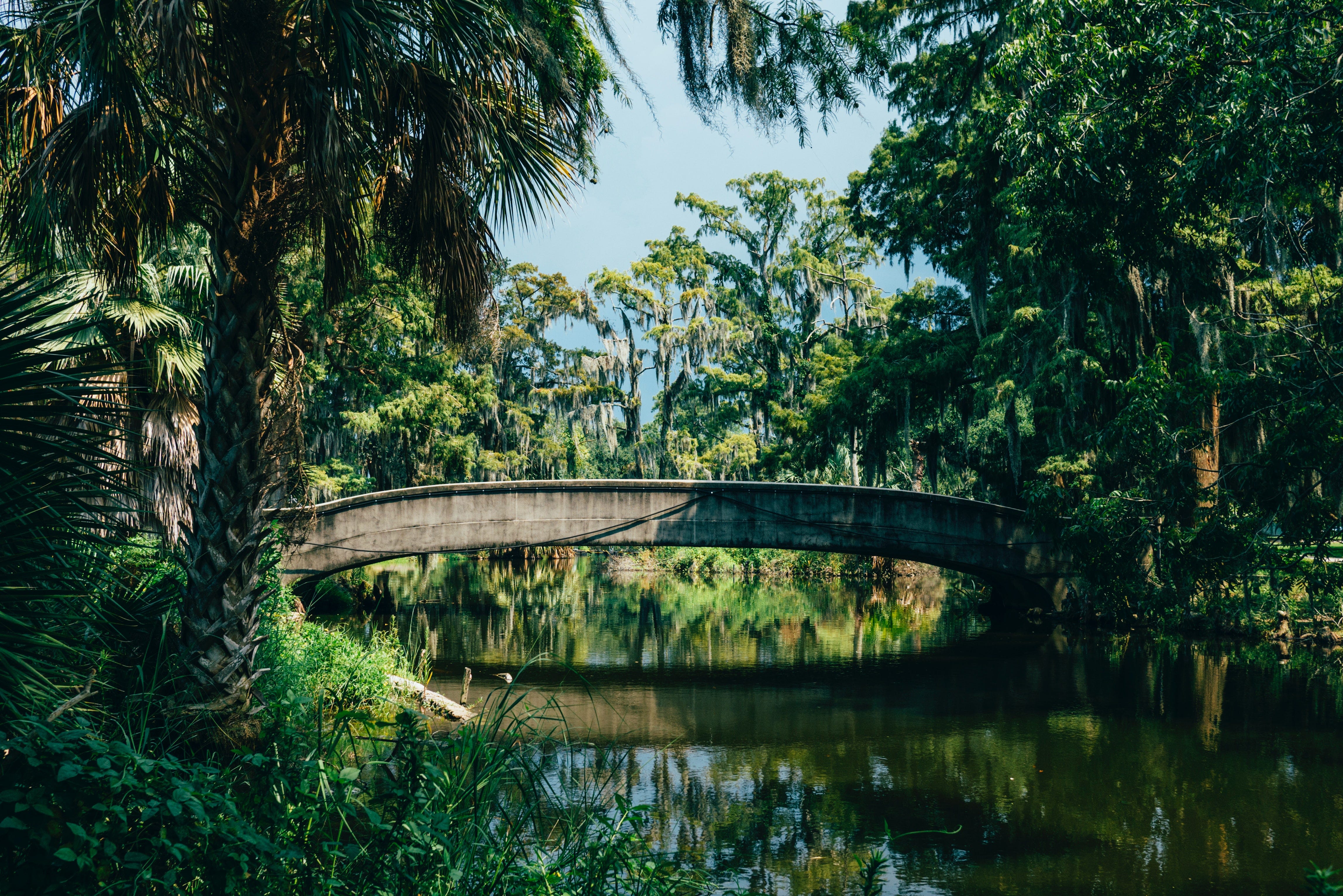
The other geological curiosity that is key to understanding New Orleans is its upside-down shape. You may think that land should rise as you walk away from a river, but that’s only the case where a river has carved out its valley; here, in a land that is built by the river, the highest ground is along the banks.

This fact will help you grasp the local ecosystems. Certain trees, like live oaks, thrive best on the “high” ground, though it’s rarely higher than a few meters above sea level. As the land drops a bit lower, cypress trees appear in the swamps. Beyond the cypress swamps lie marsh grasses that can tolerate the brackish water washing in from the Gulf. This is all fragile terrain, as a viewing platform in the Lower 9th Ward demonstrates: here the remnants of a cypress forest—once home from “maroons” who refused enslavement—are visible as thin, ghostly trunks. The forest was killed by salt water, which snuck inland after a channel for ships was dredged nearby.
Much of modern New Orleans is built atop former wetlands. To “reclaim” this ground, the city built an elaborate system of drainage canals that carry water out of the city. Watch closely as you travel through the city and you may notice the pumps that push rainwater off the streets, into the canals.
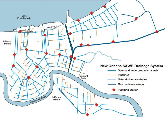
There’s one big problem with this system: the pumps wind up lowering the water table. The ground in the city is sinking. In the 1970s, as new suburbs grew just west of the city, several homes sunk enough to disconnect from the gas system, resulting in explosions. Historian Andy Horowitz has found that the greatest predictor of whether or not someone’s house flooded during Hurricane Katrina was not race or class, but when their neighborhood was developed. The newer neighborhoods, built atop former swamps and marshes, fared worst. (To learn more about the storm, visit the Flooded House Museum.)
🌳🐦🐊 A City Park Safari
One stretch of green space was exempted from development. New Orleans City Park spans 1,300 acres. Though it’s far from wild, it’s still the best place in town to find many of Louisiana’s iconic species.
When you think of the South, you may picture a live oak, clad in Spanish moss, dripping with resurrection ferns. City Park’s “Old Grove” features the largest grove of mature live oaks in the world, including one 800-year-old behemoth. These trees once stood along the banks of Bayou Metairie, portions of which remain in the form of lagoons. (Two other oak trees worth seeking: the nearby “Singing Oak,” which is hung with wind chimes, and the delightfully gnarled “Tree of Life” across town in Audubon Park.)
As noted above, you can sometimes find alligators in Bayou St. John—especially on the southern edge of Demourelles Island. City Park removes its gators, though north of I-610, they wait until they’re at least 5 feet long. (The park offers a handy guide to what to do if you see one.) The trails on the edge of Scout Island and Couturie Forest—two of the more natural areas in the park—are good sites for gator sighting. You’ll like to spot ibis and egrets and herons, too, New Orleans’s familiar but always-elegant birds.
Finally, the baldcypress once lined the Mississippi River as far north as Missouri. But when settlers found outs its wood resists rot, its timber became desirable. Now they’re hard to find anywhere—City Park included. There are a few good specimens in the trails along the bayou in the Wisner Tract, though it’s worth noting that this area is a de facto off-leash dog park. The Native Plant Trail includes a little nook that gives a nice approximation of the swamps, too. For a full forest, you’ll have to get out of the city—so read on.
🦀🦐🐟 Eating the Seascape
Perhaps the best way to experience Louisiana’s wildlife is to eat it. The marshes to the south of the city include a gradient of water, from fresh to brackish, a fact that helps support an explosion of life.
Here are some of my favorite spots to eat the classics. For the most part, I’m recommending simple preparations here—which are both good for the wallet and the best way to taste the flavor of the seas!
🦪 Oysters: The classic joint—more than 100 years old now—is Casamento’s. The oyster loaf is famous, but it’s a great place to get raw oysters, too. In the French Quarter, I tend to skip the line at Acme and head to Felix’s bar on Bourbon Street.
Gulf oysters are famously big and briney—and they’re excellent. But if you’re used to more delicate bivalves, you might prefer the “cultivated” Gulf oysters, which are raised on offshore farms. Seaworthy and Sidecar are reliable spots for a tasting from a few farms.
🦐 Shrimp & crab (and whatever else is on the menu): Mosquito Supper Club is perhaps my favorite restaurant in the city. Chef Melissa Martin buys her seafood direct from the fishers—who are sometimes her family members—and works to keep traditional Cajun recipes alive. The prix fixe menu, though excellent, may be too $$$ for some diners. But the bar offers snacks at more affordable prices. (If you want to know more about what you’re eating, head to our archives for details on shrimp both brown and white.)
Catfish: These aquatic beasts live on every continent, but somehow they’ve become synonymous with the South. There’s no better place in the city to taste them than Barrow’s, whose original menu in 1943 had just one entree: catfish, deep fried. There’s more on offer now, but the classic remains the reason to come.
Crawfish: There’s nothing better than springtime in Louisiana because it means hot boiled crawfish. Every local will have their own favorite, but a few years ago I stumbled into Captain Sid’s, in Bucktown, and was immediately wowed. Grab a sack and go gaze across Lake Pontchartrain.
Bycatch: The word may sound unpalatable, but if you care about the ocean ecology, this is what you should be eating: lesser-known species that have been caught in fishing nets and, despite being delicious, are often trashed. Chef Dana Honn makes it a point to seek out such sustainable species, which is part of why Carmo is the only restaurant in the state certified by SeafoodWatch.
Want to get fancier? A few years back, Brett Anderson created this excellent guide to the city’s classic seafood dishes. A few of these restaurants are closed, sadly, but the survivors are all worth visiting.
📚 Required reading
There’s something a little freaky about sitting in this city and reading John McPhee’s classic essay “Atchafalaya,” which is about New Orleans’s inevitable doom by river. The essay can be found online, though it’s worth tracking down the full version in the book The Control of Nature.
The National Book Award-winning memoir The Yellow House, by Sarah Broom is at once a Katrina story and a portrait of the city’s expansion into an often-overlooked region: New Orleans East arose from the swamps in the 1950s, and stretches more than 20 miles east from the more familiar parts of the city.
🚗 Beyond the city
If you’ve got time enough to get out of town, then head east upriver to the Whitney Plantation. Many of the old sugar plantations have been converted to museums, but the Whitney is the only one that keeps the story focused where it should be: on the life of the Black families that did the actual work.
Just south of the city, Barataria Preserve is an excellent place for a walk through the cypress swamps. It’s part of Jean Lafitte National Park, which is named for the famous buccaneer who once slipped through the bayous here. For a guided boat tour, head west to the Atchafalaya Basin for a trip with Last Wilderness Tours: without the disruptive roar of an airboat, you might actually get to encounter the swamp’s inhabitants.
🏨 Other notes
For an indoor look at nature, visit the Ogden Museum of Southern Art and its great collection of regional landscape art. The exhibitions at the Historic New Orleans Collection are only sometimes about nature, but they’re always excellent and always free.
Looking for lodging? I recommend booking a hotel in the French Quarter. Bourbon Street may be kitchsy chaos, but the Quarter is far more than a tourist zone: it’s the most historic part of the city, and still a functioning neighborhood—and has plentiful hotel rooms that, unlike AirBnbs, aren’t diminishing the city’s housing supply. You’re also at the heart of the city, with easy access via buses, bike trails, and street cars (and ferries!) to most other places you’ll want to go. You can download the RTA app to pay for fares on public transportation. The Blue Bike program is another good transportation option.
Great guide to a more natural NO.