


A visit to the littler rock
Finding the lost history of Arkansas's capital city
Over the years, when I’ve passed through Little Rock, its placeness never resolved clearly. For me it was a waypoint—a civilized layover between my home in Mississippi’s lowlands and the mountains I was always seeking to the west. Its terrain was between, neither highland nor lowland. Just land.
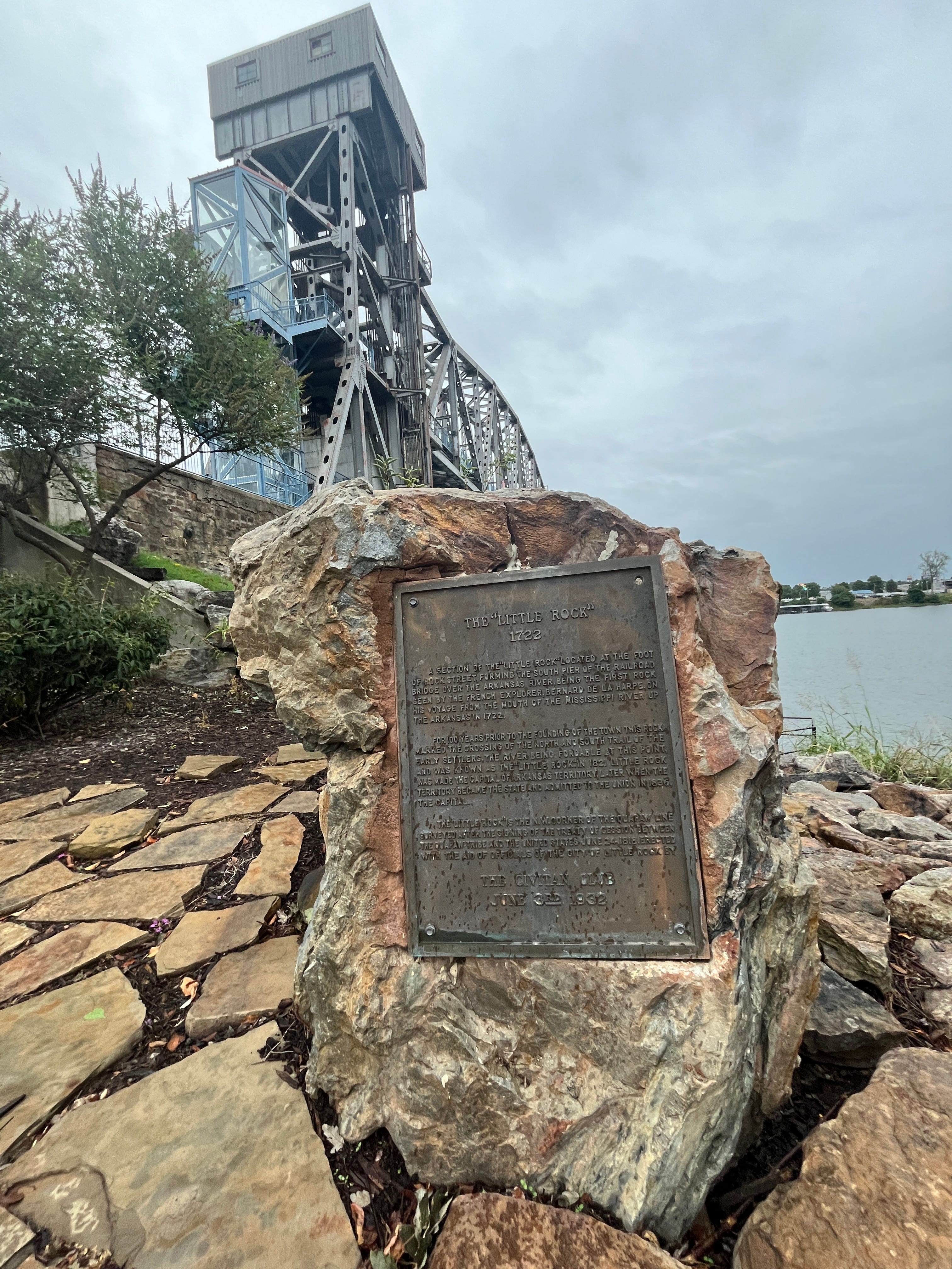
A few weeks ago, I was back in town, and hoping to be defensively stylishly late to the party where I knew I’d know no one, I spent a few minutes wandering the banks of the Arkansas River. Eventually, I stumbled across an artifact I had not known existed: a small remnant of what the French had once called le Petit Rocher. The Little Rock.
Suddenly, this city became legible.
The western edge of the Arkansas Delta is not clearly defined, in part because rivers like the Arkansas flow east here, adding their own floodplains to the big Mississippi’s.1 One good way to define the Delta’s edge is to find the first place on the rivers where, traveling upstream, you first meet on rock. On the Arkansas, that is roughly 115 miles upstream from the mouth, where the water begins to run through the sandstone foothills of the Ouachita Mountains. Centuries ago, a big stone bluff on the northern banks became known as the Big Rock; on the southern bank, a different feature was dubbed (for intuitive reasons) the Little Rock.2 The city sits at an ecotone.3
In 1818, the Quapaw were forced onto a reservation whose western boundary was this “Point of Rocks” on the Arkansas River—a fact, I can’t help but note, that meant they’d been evicted from the nation’s richest agricultural lands. Also telling is that the capital of Arkansas Territory was sited amid those luxurious floodplain soils. Eventually, that site—Arkansas Post—was deemed too much in the floodplain, too swampy. The capital was shifted upriver to the edge of the Quapaw Reservation, at the Little Rock.
There’s a joke down in Florida that every new residential development gets named for one of the species it displaces: Cypress Way, Panther Run, and so on. Generally, though, American place names are so random in their sourcing that it had not occurred to me that Arkansas’s capital was named for anything at all.4 It seems fitting, somehow, that the rock has mostly been blasted to pieces, a process that started in 1872 for a bridge that was never actually built. The rock I found, a 4,700-pound hunk, had been chipped out of the formation that remained in 1932, after several more iterations of bridge-building. Call it the Littler Rock.
Le Petit Rocher will forever be a mystery. We can see in old maps how far into the river it stretched. But how high was it? What was its shape above the water? In 1822, the Arkansas Gazette noted that the rock “projects several feet into the river, forming below it a fine basin for boats, and its top reaches perhaps about midway between low water mark and the summit of the bank of the river.” Otherwise, as the Encyclopedia of Arkansas notes, “visual sources for how the Point of Rocks looked before progress took its toll are rare and ambiguous.”
The Littler Rock, meanwhile, lived for years near City Hall;5 active rail lines crossed the river at the Point of Rocks, making the original site too dangerous for visitors. In 2009, finally, with the railroad defunct, the Littler Rock was moved back to its birthplace. But, due to its “lack of physical prominence” (as one of the surrounding placards puts it), no one bothered to hold a commemoration. The next year, finally, a plaza opened around the Littler Rock, providing a reason for a party.
To me, it’s a rather two-faced monument—a testament to the fact that everywhere is nature but also to the way so much of that nature has been blasted apart.
If you go
Even if my visits have been sparse, I have accumulated two key recommendations for those of y’all heading to (or through) Little Rock: The Root Café makes good food from local produce; White Water Tavern is the spot for drinks and music (owner Matt White is a mensch). There’s a lot I hope to explore on future visits, from all the bike trails to nearby hiking in Pinnacle Mountain State Park, and, over by the Big Rock, Emerald Park. You can paddle, too, though thanks to the locks and dams, the water of the Arkansas is as altered as the Littler Rock. Got further recs? Drop them in the comments, pleas.
It took a full footnote early on in The Great River to explain the meaning the word “delta,” which I guess I’ll repeat here. There’s the Mississippi River’s delta, lowercase, a technical geological term for the murky lands in Louisiana, the long tongues of mud that reach out into the Gulf. And then there is the more ambiguous, big-D “Delta,” a name applied to almost any land along the Lower Mississippi River that once received its floodwaters. As I note in the book, it seems as if the river’s lowlands were “so distinct from anywhere else in the country that it is obvious to everyone” that they are a region apart. (On the east side of the river, by the way, the Mississippi Delta is a well-defined place. The bluffs arise, suddenly and undeniably, demarcating an edge.)
The first Frenchman to chart this stretch of the river didn’t even bother to name the Little Rock, though his notes contain what sounds like a description, in just about the right place: “We found rocks sticking up from the ground.” The Big Rock did get a name—“le Rocher Français,” back then, or the French Rock. The French guy in question, Jean-Baptiste Bénard de La Harpe, suggested this was a good site for a trading post—a hundred years before a settler community was ever established.
A meeting place of three different terrains, in fact: to the east, there’s the rivers’ alluvial plains; to the west and northwest, the Ouachita uplands; but the southwest unfurls the beginnings of the Atlantic coastal plain.
There was for a time a rival name Arkopolis, pushed by a rival group of settlers; when they lost a legal fight over overlapping land claims, their (inferior) name was cast aside.
With, apparently, a time capsule stuck inside.
Thanks, Boyce. I’m often struck with wonder and imagination as I read your descriptions of places I haven’t been or fully explored. However, reading your observations and objective assessment of a place I have known and pondered all my life is no less eye opening. Living in Lonoke (20 minutes east of the Littler Rock, a town we call “The Front Porch of the Delta”) I am perpetually considering the change in terrain and geology that occurs at this point. Your words have added another layer of clarity for me to consider my home.
…and next time you come through, stop over here in Lonoke and we will take you to dinner at The Grumpy Rabbit downtown!
Ecotone is a new term for me, but it explains in a single word why trips as a kid were always west of the suburb of Little Rock I grew up in, typically heading to the Ouachita region with its lakes, rivers, and rolling hills. An uncle of mine would mess with me and refer to Little Rock as Flat Rock, though over time it seemed appropriate as I really didn't experience any elevation in Little Rock.